|
|
|
|
|
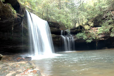
South Caney Creek Falls |
|
Wren, AL |
|
|
|
|
|
South Caney Creek Falls |
|
Wren, AL |
| South Caney Creek Falls is a well hidden, beautiful feature located inside of Bankhead National Forest. On a beautiful day after a good rain you can hear it a little ways up the trail, beckoning the hiker to come and see the beauty that lies in the hidden canyon. Further down the stream, for the adventurous at heart lies more natural features. However, be warned the trail is not established and it is extremely hard hiking and can be dangerous. | |
|
|
|
| Activities: | Hiking, Photography, Waterfalls |
| Location: | Wren, AL |
| Directions: | I have not had a chance to recheck these directions yet, however I feel some people may enjoy trying to find Caney Creek anyways. Use directions at your own risk. From Huntsville take I-565 heading toward Decatur, to I-65 South. Take Exit 328 (Highway 36W) thru Hartselle to Wren. In Wren 36W will dead end at Highway 33. Turn left (Highway 33S) and follow it to Hwy 2 (just before the Sipsey River Bridge). Go west on Hwy 2 for about 3.7 miles, there is an old USFS road with a gate on the right side down in the dip, park on the side (do not block the road entrance). |
| Trails: | Caney Creek Falls (approx. 1 mile) |
| Topography: | Rivers, creeks, waterfalls, forest, hills, canyons, old growth forest |
| Hiking Information: | Ticks can be an issue on this trail, it is not recommended to hike during the warm weather. Even though the water may look clean, do not drink it without purification. This trail has a couple of downed trees. The middle of this trail is desolate due to the cutting that has been done over the years. |
| Trail Map: | Trail map can be purchased at Wild Alabama Trading Post |
| Photo Album: | |
Return to Southeast Hiking Main Page
Page Updated: January 29, 2005